Topography
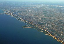
Chicago is located in northeastern Illinois at the southwestern tip of Lake Michigan. It sits on a continental divide at the site of the Chicago Portage, connecting the Mississippi River and the Great Lakes watersheds. The city lies beside freshwater Lake Michigan, and two rivers—the Chicago River in downtown and the Calumet River in the industrial far South Side—flow entirely or partially through Chicago. The Chicago Sanitary and Ship Canal connects the Chicago River with the Des Plaines River, which runs to the west of the city. Chicago's history and economy are closely tied to its proximity to Lake Michigan. While the Chicago River historically handled much of the region's waterborne cargo, today's huge lake freighters use the city's Lake Calumet Harbor on the South Side. The lake also provides another positive effect, moderating Chicago's climate; making waterfront neighborhoods slightly warmer in winter and cooler in summer.
When Chicago was founded in 1833, most of the early building began around the mouth of the Chicago River, as can be seen on a map of the city's original 58 blocks.The overall grade of the city's central, built-up areas, is relatively consistent with the natural flatness of its overall natural geography, generally exhibiting only slight differentiation otherwise. The average land elevation is 579 ft (176 m) above sea level. The lowest points are along the lake shore at 577 ft (176 m), while the highest point, at 735 ft (224 m), is a landfill located in the Hegewisch community area on the city's far south side.
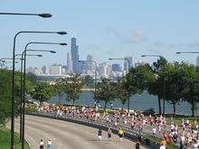
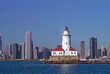
The Chicago Loop is the central business district but Chicago is also a city of neighborhoods. Lake Shore Drive runs adjacent to a large portion of Chicago's lakefront. Some of the parks along the waterfront include Lincoln Park, Grant Park, Burnham Park and Jackson Park. 29 public beaches are also found along the shore. Landfill extends into portions of the lake providing space for Navy Pier, Northerly Island, the Museum Campus, and large portions of the McCormick Place Convention Center. Most of the city's high-rise commercial and residential buildings can be found close to the waterfront.
An informal name for the Chicago metropolitan area is Chicagoland, used primarily by copywriters, advertising agencies, and traffic reporters. There is no precise definition for the term "Chicagoland," but it generally means the city and its suburbs together. The Chicago Tribune, which coined the term, includes the city of Chicago, the rest of Cook County, eight nearby Illinois counties: Lake, McHenry, DuPage, Kane, Kendall, Grundy, Will and Kankakee, and three counties in Indiana: Lake, Porter and LaPorte. The Illinois Department of Tourism defines Chicagoland as Cook County without the city of Chicago, and only Lake, DuPage, Kane and Will counties. The Chicagoland Chamber of Commerce defines it as all of Cook and DuPage, Kane, Lake, McHenry and Will counties.
Climate
The city lies within the humid continental climate zone, and experiences four distinct seasons. Summers are hot and humid, with a July daily average of 84.7 °F (29.3 °C). In a normal summer temperatures exceed 90 °F (32 °C) on 21 days. Winters are cold, snowy, and windy, with some sunny days, and with a January average of 23.5 °F(−4.7 °C). Temperatures often (43 days) stay below freezing for an entire day, and subzero lows occur on eight nights per year. Spring and fall are mild seasons with low humidity.
According to the National Weather Service, Chicago's highest official temperature reading of 107 °F (42 °C) was recorded on June 1, 1934 and July 11, 1936, both at Midway Airport. The lowest temperature of −27 °F (−33 °C) was recorded on January 20, 1985, at O'Hare Airport. The city can experience extreme winter cold spells that may last for several consecutive days.
No comments:
Post a Comment